The Adopt-a-Plot wetland reclamation reserve
This reserve, part of the Inlet Walkway Reserve, is an outstanding example of how dedicated community groups can make a huge difference to the quality of life in Motueka. It's also simply a wonderful place to spend a peaceful hour or two in an unusual, scenic setting.
Adopt a Plot is an initiative of the hard-working Keep Motueka Beautiful (KMB) volunteer committee, which over the past decade or so has transformed (and is still transforming) a huge old sawdust dump into reclaimed wetlands linked by a maze of walking tracks.
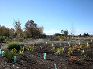
Simply put, KMB prepares each plot by grading, pathing, rotary-hoeing and mulching and providing the plants - all chosen as natives to the coastal inlet environment. Citizens (families, individuals or groups) adopt a plot and care for the plants with water, weeding and fertilisers. At the time of writing, 23 plots have been adopted and the final five are being prepared.
You can reach the area by the Inlet Walkway from South Motueka (for example, via the footpath near Up The Garden Path restaurant), but it's easiest to visit from Old Wharf Road. The entrance is directly opposite the main entrance to the Recreation Centre, beside the floodwater drain where it empties into the inlet.
Most people will find the experience more complete if done when the tide is in, but if you also enjoy viewing mudflats then any time will do. The wide crushed gravel paths are very easy to negotiate, either by cycle or foot, though as they twist a lot and there is such a lot to see, walking is far more satisfying and relaxing.
The plots themselves start only about 50 metres from the Old Wharf Road entrance, and there you find a map on a noticeboard attempting to show where the plots are and how they connect together. Because work is proceding so quickly, the map is a little out of date but it does show where the main paths are, particularly the perimeter ones, and the general location of all but the latest plots.
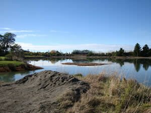
Start out taking the left hand path to the inlet and the built up perimeter path. The view from the north eastern corner, where the gravel is heaped for future use, is breathtakingly peaceful and expansive, specially on a good day and with the tide in. (See the top photo on the right and the one at the end of this page on the left.)
Follow the stopbank to its end and turn back in to the right, joining up with the Inlet Walkway where the final plots are being prepared. Note to the right the extensive reed beds at the high tide level, which will not be turned into plots.
From there, stroll amongst the various plots along the many paths between them. You can't get lost, but you will become immersed. Flaxes of various ages dominate, along with many familiar coastal natives.
There are several seats installed at various suitable spots, encouraging you to pause, sit and ponder. All seem to have been donated as memorial fixtures. There are even a few picnic spots, with tables and seating.
KMB acknowledges the help of Tasman District Council, the Community Trust and the Lion Foundation, as well as local businesses and donors, to make this reserve possible.
 |
 |
If you have a favourite thing you like to do - a walking place, attraction, quiet spot - so the rest of us can check it out and enjoy it too, please tell us about it here.